Randonnée Randonnée équestre Val d'Oingt - Oingt Theizé samedi après-midi bodipido 2024 - Photo

Oingt Theizé samedi après-midi bodipido 2024

 chevaltaiga
chevaltaiga

Utilisateur

© OpenStreetMap contributors
Longueur
Longueur
10,4 km
Altitude max
Altitude max
650 m
Dénivelé positif
Dénivelé positif
323 m
Km-Effort
Km-Effort  
15 km
Altitude min
Altitude min
403 m
Dénivelé négatif
Dénivelé négatif
389 m
Boucle
Boucle
Non
Date de création :
2024-04-04 07:12:20.282
Dernière modification :
2024-04-04 07:13:25.448

(0 Avis)

Randonnée équestre
Randonnée équestre
1h58
Difficulté : Facile

Scannez ce code QR pour ouvrir la randonnée dans l'application SityTrail

Application GPS de randonnée GRATUITE

Logo SityTrail SityTrail

IGN / Instituts géographiques

Télécharger SityTrail sur l'App Store Télécharger SityTrail sur Google Play

Logo SityTrail SityTrail World

Le monde est à vous

Télécharger SityTrail sur l'App Store Télécharger SityTrail sur Google Play Télécharger SityTrail sur Huawei AppGallery

À propos

Randonnée Randonnée équestre de 10,4 km à découvrir à Auvergne-Rhône-Alpes, Rhône, Val d'Oingt. Cette randonnée est proposée par chevaltaiga.

Profil altimétrique

Localisation

Pays :
France
Région :
Auvergne-Rhône-Alpes
Département/Province :
Rhône
Commune :
Val d'Oingt
Localité :
Oingt
Départ:(Dec)
Départ:(UTM)
622776 ; 5089228 (31T) N.

Randonnées à proximité

Randonnée Marche Ternand - Ternand - Létra - Photo
Marche
daniellebou

Marche

Très difficile
(1)
Ternand, Auvergne-Rhône-Alpes, Rhône, France
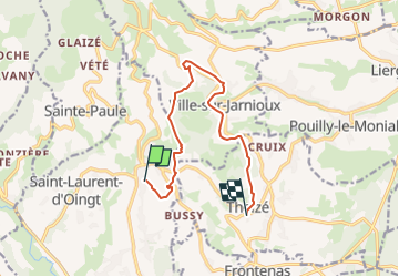
17,8 km | 27 km-effort
6h 7min
Oui
Randonnée Marche Val d'Oingt - Oingt (69) Beaujolais  - Photo
Marche
Thomasdanielle

Marche

Très facile
(1)
Val d'Oingt, Auvergne-Rhône-Alpes, Rhône, France
9,3 km | 13,3 km-effort
2h 30min
Oui
Randonnée Marche Saint-Vérand - Saint Vérand - Photo
Marche
fernand1254

Marche

Moyen
(1)
Saint-Vérand, Auvergne-Rhône-Alpes, Rhône, France
13,5 km | 21 km-effort
3h 37min
Oui
Randonnée A pied Légny - De Saint Vérand à Bagnols - Photo
A pied
PRO

A pied

Facile
Légny, Auvergne-Rhône-Alpes, Rhône, France
7,4 km | 10,3 km-effort
2h 20min
Non
Randonnée Marche nordique Bagnols - bagnol - Photo
Marche nordique
isabelle.xavier

Marche nordique

Très facile
(1)
Bagnols, Auvergne-Rhône-Alpes, Rhône, France
6,8 km | 8,4 km-effort
1h 40min
Oui
Randonnée Vélo électrique Val d'Oingt - tour dans le beaujolais Oingt - Salles sur Arbuissonnas - Photo
Vélo électrique
cailloux54

Vélo électrique

Moyen
(1)
Val d'Oingt, Auvergne-Rhône-Alpes, Rhône, France
52 km | 68 km-effort
5h 44min
Oui
Randonnée Marche Sainte-Paule - Sainte-Paule (13,4 km D. 485 m) - Photo
Marche
Thomasdanielle

Marche

Moyen
(1)
Sainte-Paule, Auvergne-Rhône-Alpes, Rhône, France
13,4 km | 19,4 km-effort
4h 9min
Oui
Randonnée Marche Val d'Oingt - 69620-StLo-160412-Azergues+Genetière+Berthier - Photo
Marche
adye

Marche

Facile
(2)
Val d'Oingt, Auvergne-Rhône-Alpes, Rhône, France
5,2 km | 7,1 km-effort
1h 38min
Oui
Randonnée Marche Val d'Oingt - Saint-Laurent d'Oingt - Oingt, Plus beau Village de France - Photo
Marche
adye

Marche

Difficile
Val d'Oingt, Auvergne-Rhône-Alpes, Rhône, France
8,8 km | 12,5 km-effort
2h 20min
Oui


Fermer
Mes abonnements